· Guides · 10 min read
Fishing Access Rights: Stream Access Laws by State — Can You Wade That River? (2026)
Reviewed by FishKillFlea Editorial Team
Montana says yes, Colorado says no, and Utah just made it harder. The complete guide to stream access laws, public trust doctrine, and your right to fish America's rivers.
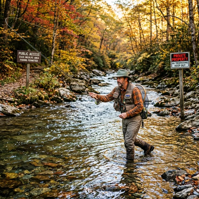
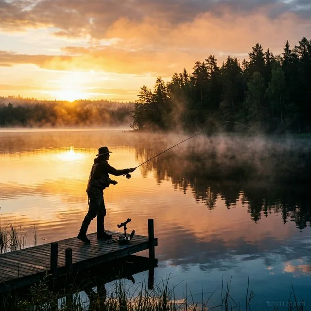
You’re standing in a crystal-clear trout stream, fly rod in hand, when a landowner appears on the bank and tells you you’re trespassing. Are you? The answer depends entirely on which state you’re in — and maybe which court ruling you cite. Stream access rights are the most contested and misunderstood area of fishing law in America, and getting it wrong can mean a trespassing charge.
This guide maps every state’s approach to the central question: Can you legally wade in a river that flows through private property?
The Core Legal Concepts
Before diving into state-by-state rules, you need to understand three legal doctrines that determine your fishing access rights:
1. The Public Trust Doctrine
The idea that certain natural resources — including navigable waterways — belong to the public and cannot be privately owned. States that strongly adopt this doctrine tend to guarantee public fishing access on all navigable waters, regardless of who owns the riverbed.
Strong Public Trust states (broad access): Montana, Oregon, Washington, Minnesota Weak/No Public Trust (restricted access): Colorado, Utah, many eastern states
2. The Navigability Test
Whether a waterway is “navigable” determines public access rights — but states define “navigable” very differently:
| Definition | Standard | States Using This |
|---|---|---|
| Federal navigability | Was the water used for commercial navigation at statehood? | Used for federal title purposes only |
| Recreational navigability | Can a canoe, kayak, or raft float on it? | MT, OR, WA (more permissive) |
| Commercial-only navigability | Was it commercially navigable at statehood (1800s)? | CO, UT (very restrictive) |
The navigability trap: A river can be navigable for fishing purposes in one state and non-navigable in the adjacent state, even for the same river, because each state uses its own legal test.
3. The Ordinary High-Water Mark (OHWM)
In states with public access rights, the OHWM is the legal boundary between public and private. Below it = public; above it = private. The OHWM is typically identified by:
- Vegetation line (where permanent bank vegetation stops)
- Debris line from normal water levels
- Erosion marks on the bank
- Color changes in soil/rock

Pflueger President Spinning Reel
Smooth 10-bearing system. Great value for freshwater fishing.
Affiliate link · Prices may vary
The 50-State Access Map
🟢 Full Public Access States (You Can Wade)
These states give anglers the right to wade, walk, and fish in rivers and streams up to the ordinary high-water mark, even when the riverbed is privately owned:
| State | Legal Basis | Key Rule | Access Points |
|---|---|---|---|
| Montana | 1972 Constitution + Stream Access Law (1985) | All waters capable of recreational use are public below OHWM | Must enter from public land, bridge, or FWP access site |
| Oregon | Public Trust Doctrine + state statutes | Public owns all navigable waterways | Access via public roads, boat ramps, state lands |
| Washington | Public Trust Doctrine | All navigable waters are public | Similar to Oregon |
| Idaho | State Constitution | Right to fish in all natural waterways | Access can be limited on some private-land rivers |
| New Mexico | State Constitution | All waters belong to the public | Non-navigable creeks may still be restricted |
| Minnesota | Public Trust + strong statutory framework | Navigable waters are public; includes most meandered lakes and rivers | Extensive DNR access site network |
| Alaska | State Constitution | All navigable and fish-bearing waters are public | Remote access often by plane/boat |
| Wyoming | State law (with nuance) | Can wade streams below OHWM; cannot cross private land to access | Must enter legally — bridge, public access, etc. |
| Michigan | Public Trust Doctrine | All navigable waters open for wading below OHWM | Extensive access site system |
| Wisconsin | State Constitution + Public Trust | Strong public access tradition | DNR maintains comprehensive access sites |
Montana is the gold standard. Its 1985 Stream Access Law, upheld by the Montana Supreme Court in Galt v. State (1987) and PPL Montana v. Montana (U.S. Supreme Court, 2012), established that the public has an irrevocable right to use all waters capable of recreational use. The state cannot give away this right, and private landowners cannot restrict it below the OHWM.
🟡 Partial Access States (Float But Don’t Touch)
These states allow public floating on rivers through private property but restrict or prohibit wading/walking on the privately-owned riverbed:
| State | Rule | What You CAN Do | What You CANNOT Do |
|---|---|---|---|
| Colorado | People v. Emmert (1979) | Float in a boat/raft through private property | Wade, anchor, or touch the streambed on private land without permission |
| Utah | Public Waters Access Act (2010) | Float and fish from a vessel while continuously moving | Wade, stand, anchor, or stop on private streambed |
| North Dakota | Limited streambed rights | Float navigable waters | Wading rights limited on non-navigable streams through private land |
Colorado’s battle:
- 1979: People v. Emmert — CO Supreme Court ruled even floating over a private streambed is trespass if you touch the bed
- 2023: Hill v. State — Angler Roger Hill argued the Arkansas River was historically navigable; CO Supreme Court denied standing
- 2026: Colorado Stream Access Coalition pushing for “right to float” legislation that would allow incidental streambed contact and portage
Utah’s lockdown:
- 2010: Public Waters Access Act restricted access to 43% (~2,700 miles) of fishable waters
- 2023: UT Supreme Court upheld the 2010 Act
- 2025: New bill (H.B. 386) seeks to further narrow the definition of “navigable waters”
- 2025: New state law requires hunting/fishing license to access certain WMAs even for non-fishing activities
🔴 Restrictive Access States (Private Streambed = No Public Rights)
These states give landowners control over the streambed beneath the water on their property:
| State | Rule | Practical Impact |
|---|---|---|
| Many Eastern states (varies) | Riverbed ownership follows property deed | Wading in front of posted private property can be trespassing |
| Virginia | Common law riparian rights | Stream access limited to navigable tidal waters + public access points |
| Pennsylvania | Mixed — navigable waters are public, non-navigable are private | Many popular trout streams flow through private land with restricted access |
| New York | Complex — navigable waters public; “navigability” narrowly defined | Some famous trout rivers run through private land with limited access |

Ugly Stik Elite Spinning Rod
Premium Ugly Stik with improved sensitivity and lighter weight.
As an Amazon Associate, we earn from qualifying purchases. Prices may vary.
How to Find Public Fishing Access
Official State Resources
Every state maintains maps and databases of public fishing access sites:
| Resource Type | What It Shows | Best For |
|---|---|---|
| State FWP/DNR access site maps | Official boat ramps, fishing access points, trails | Finding guaranteed legal access |
| State public land maps (BLM, USFS, State Trust) | Federal and state land boundaries | Determining if you’re on public or private land |
| onX Hunt/Fish app | Private/public land overlay on topo maps | Real-time in-field boundary verification |
| Google Earth (satellite view) | Visual identification of access roads, parking areas, boat ramps | Pre-trip planning and scouting |
Using Google Maps for Access Planning
Google Maps can be a powerful pre-trip tool for identifying fishing access:
Tip: Search for “[State] fishing access site” + the river name on Google Maps. Most state FWP access points appear as mapped locations with directions, parking info, and often user reviews noting conditions.

Penn Pursuit IV Spinning Combo
Rod and reel combo ready to fish out of the box. Great value for new anglers.
Affiliate link · Prices may vary
The 5 Most Fought-Over Rivers in America
1. Arkansas River, Colorado
The most litigated stream access case in the West. Angler Roger Hill spent over a decade arguing the Arkansas was historically navigable at statehood — which would grant public access to the riverbed. The Colorado Supreme Court dismissed his case on standing grounds in 2023, but the underlying question remains unresolved.
Status: Privately-owned streambed. You can float but cannot wade without permission.
2. Weber River, Utah
A 2017 Utah Supreme Court ruling declared a section of the upper Weber River navigable based on historical evidence, granting public recreational access on that specific segment. This was a rare victory for public access in Utah.
Status: Partial public access on the upper segment; rest of the Weber is restricted.
3. Madison River, Montana
Not contested legally (Montana’s Stream Access Law covers it), but heavily contested socially. The Madison is one of the most crowded trout rivers in America, with debates about guided trip limits, walk-wade vs. float access, and the impact of recreational pressure on wild trout populations.
Status: Full public access below OHWM. Crowding is the issue, not legality.
4. South Platte River, Colorado (Cheesman Canyon)
One of Colorado’s premier wild trout fisheries, flowing through a mix of Denver Water property, USFS land, and private ranches. Access depends entirely on which section you’re on — public land sections are freely accessible; private sections require landowner permission even to wade.
Status: Patchwork access. Use onX or USFS maps to identify public vs. private segments.
5. Green River below Flaming Gorge Dam, Utah
World-class tailwater trout fishery. The river flows primarily through public land (BLM and Ashley National Forest), making access relatively straightforward — a rarity in Utah’s otherwise restrictive access landscape.
Status: Primarily public access via BLM and USFS land. One of Utah’s most accessible premium fisheries.
Practical Rules to Stay Legal
✅ Universal Rules (Apply Everywhere)
- Always have your fishing license on your person — license checks happen most often at access points
- Enter the water from a legal access point — public roads, bridges, boat ramps, or public land
- Never cross fenced/posted private property to reach water — even in “full access” states like Montana, you must enter legally
- Respect the OHWM — in public access states, stay below the high-water mark. Don’t walk on the grassy bank through private property
- Carry a land ownership map — onX, Gaia GPS, or your state’s public land map. Know where public land boundaries are before you wade
⚠️ Context-Dependent Rules
| Situation | What To Do |
|---|---|
| Landowner confronts you while wading | Stay calm. If you’re below OHWM in a public access state, politely explain the law. If unsure, leave and verify |
| ”No Trespassing” sign on the bank | The sign applies to the land ABOVE the OHWM. In full access states, you can still wade below it. In restrictive states, leave |
| Need to portage around obstacle | In most states, you can briefly exit the water to walk around (portage) — but take the most direct route and re-enter the water immediately |
| Private bridge crosses the stream | You can wade under it (below OHWM) but cannot climb onto it or use it for access without permission |
| Ice fishing on a frozen stream | Same rules apply — if you’d have access in summer, you have access when frozen. Access from legal entry points |
2025–2026 Legislative Watch
| State | Bill/Issue | Status | Impact |
|---|---|---|---|
| Colorado | Stream Access Coalition “Right to Float” bill | Proposed for 2026 legislative session | Would allow incidental streambed contact while floating — massive change if passed |
| Utah | H.B. 386 — Redefining “navigable waters” | Introduced February 2025 | Would further restrict public access by narrowing navigability definition |
| Utah | WMA access law | Effective May 2025 | Requires fishing license to access WMAs even for hiking/birdwatching |
| Tennessee | Court ruling on warden property access | 2024 ruling, appeals ongoing | Could affect Open Fields Doctrine application for stream enforcement |
Frequently Asked Questions
Can I wade in a river that flows through someone’s property? In about 15 states (Montana, Oregon, Idaho, Alaska, etc.), yes — as long as you stay below the ordinary high-water mark and enter from a legal access point. In Colorado, Utah, and most eastern states, the streambed under the water may be privately owned, making wading a trespass. Check the state tables above.
Does “navigable” mean I can access it? Not always. “Navigable” has different legal meanings in different states. In Montana, if you can float a canoe on it, it’s navigable and public. In Colorado and Utah, navigability requires evidence of historical commercial use — a much higher bar that excludes most rivers.
Can a landowner block a river? Generally no — blocking the flow of a navigable waterway is illegal under federal law. However, a landowner CAN prevent you from accessing the water by crossing private land. You must find a legal entry point (public road, bridge, public land boundary).
What is the ordinary high-water mark? The OHWM is the level at which the water has been long enough to leave a visible mark — usually identified by the vegetation line, debris, or soil discoloration. Below this mark is typically public; above it is private. It’s not the same as the current water level.
I saw a “No Fishing” sign. Is it enforceable? It depends. If the sign is on private land above the OHWM, it applies to the land, not the water below it (in public access states). If the sign is placed by a state agency (e.g., spawning closure, restricted area), it IS enforceable. When in doubt, check with your state fish & wildlife agency.
What’s the best app for knowing where I can legally fish? onX Hunt/Fish is the most popular tool — it overlays public/private land boundaries on satellite imagery. Gaia GPS and your state’s official fish & wildlife app are also excellent. Always cross-reference with official state access maps.
For license costs, see our Cost Guide. For rules about fishing on private land without a license, see our Private Property Guide. For multi-state trip planning, see our Reciprocity Guide and Multi-State Guide.